Um die Punkte innerhalb Ihrer Bounding-Box-Abfrage, aber nicht innerhalb des Polygons zu eliminieren, müssen Sie Point in Polygon verwenden Algorithmus.
Der einfachste Weg, dies zu tun, besteht darin, die Koordinaten in Arrays zu haben. Diese können verwendet werden, um maximale und minimale Koordinaten für die Abfrage und für Parameter für die Funktion pointInPolygon() zu finden.
function pointInPolygon(polySides,polyX,polyY,x,y) {
 var j = polySides-1 ;
  oddNodes = 0;
  for (i=0; i<polySides; i++) {
    if (polyY[i]<y && polyY[j]>=y  ||  polyY[j]<y && polyY[i]>=y) {
        if (polyX[i]+(y-polyY[i])/(polyY[j]-polyY[i])*(polyX[j]-polyX[i])<x)  {
            oddNodes=!oddNodes;
        }
    }
   j=i; }

  return oddNodes;
}
In Ihrem Map-Code mit jQuery getJSON()
var polySides = 4;//number of points in polygon
//horizontal Latitude coordinates of polygon
var polyLat = new Array();
polyLat[0] = 51.5;
polyLat[1] = 51.5;
polyLat[2] = 52.5;
polyLat[3] = 53;
polyLat[4] = 51.5;//First point repeated to close polygon
//vertical Longitude coordinates of polygon
var polyLng =  new Array();
polyLng[0] = 0.5;
polyLng[1] = -1.9;
polyLng[2] = -1;
polyLng[3] = 0.6;
polyLng[4] = 0.5;
//Coordinates for bounding box
var maxLat = Math.max.apply(null,polyLat);
var minLat = Math.min.apply(null,polyLat);
var maxLng = Math.max.apply(null,polyLng);
var minLng = Math.min.apply(null,polyLng);

//Using jQuery
var url = "yourFile .php";
 url +="?maxLat="+maxLat +"&minLat="+minLat +"&maxLng="+maxLng +"&minLng="+minLng;
 $.getJSON(url,function(data) {
    $.each(data.marker,function(i,dat){
        if (pointInPolygon(polySides,polyLat,polyLng,dat.lat,dat.lng)){
            var latlng = new google.maps.LatLng(dat.lat,dat.lng);
            addMarker(latlng,dat.name);
            bounds.extend(latlng);
        }
    });
    map.fitBounds(bounds);
});
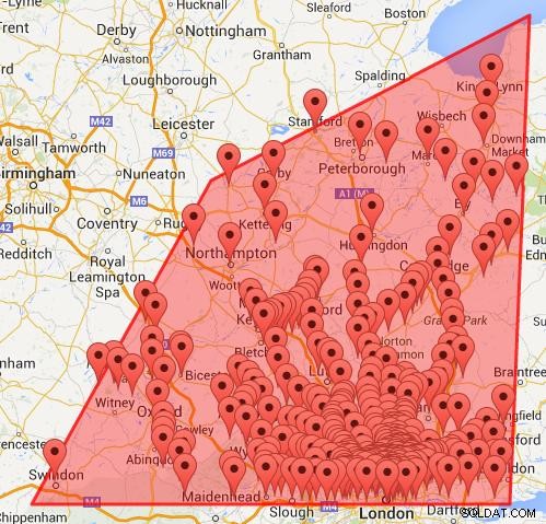
Karte erhalten mit Bounding Box und Point in Polygon.


